
Early this morning, Pacific Time (4:30 in the afternoon of Sept. 24th in Pakistan), a major earthquake, currently estimated at Magnitude 7.7, struck a sparsely populated region of Pakistan. The earthquake was both large and very shallow: although the epicenter was 20 km (12 miles) underground, preliminary slip inversions indicate that the majority of the fault motion was between the surface and about 10 km (6 miles) depth. Although the area is remote and reports are sparse, given these facts we can reasonably expect this earthquake to have severe consequences. Current reports have injuries in the range of 100-200, but the USGS PAGER report for this earthquake (http://earthquake.usgs.gov/earthquakes/eventpage/usb000jyiv#pager) indicates a likely death toll around 1000.
The last major earthquake in Pakistan, the 2005 M 7.6 Kashmir Earthquake, killed over 70,000 people. The magnitude of that death toll, especially compared with comparable earthquakes in the Western world, highlight the importance of stringent building codes and strict compliance with those codes in preventing earthquake deaths. Pakistani homes and buildings are almost all constructed of unreinforced masonry (URM), usually cinder blocks cemented with mortar and little or no steel reinforcement. These buildings may as well be mud huts in an earthquake, for all they can resist the shaking. In situations like this, earthquake warning is of minimal value. The first order of business needs to be long-term retrofitting, reinforcement and, in many cases, outright reconstruction of the building stock. Only then does earthquake warning start to provide a significant benefit, as it does in the West.
One of the more amazing reports coming out of Pakistan is that a new island has appeared off the coast of Gwadar, some 200 miles from the epicenter. As strange as it sounds, this is not unprecedented: following a M 8 earthquake near the Gwadar coast in 1945, three small islands were reported to appear, accompanied by “fireballs.” This suggests, and the local geology strongly supports the hypothesis, that these islands were mud volcanoes triggered by the earthquake, and that the fireballs were ignitions of methane gas being released from the sediments in the bottom of the ocean, which in that area is rich in shale that can store methane in large quantities. The fact that this earthquake was hundreds of miles away adds some interest to the story, because it suggests that, if this earthquake is a mud volcano, it was triggered by relatively mild shaking. Keep in mind that this report, like almost any news coming out of the region, is uncorroborated and may be untrue. The photo to the right shows the reported island, and it’s more or less all we have to go on at this point. We will learn more about the effects of this earthquake in the days and weeks to come, but one thing is certain: life in large portions of Pakistan will be very hard for many people, for a very long time.
Gilead Wurman
Chief Seismologist
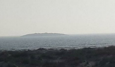
Photo of the reported new island off the Pakistani coast. Dimensions are reported to be about 1/2 mile across, ~50 feet high.
 RSS Feed